


AMap Viewer
Description of AMap Viewer
AMap Viewer is a navigation application designed for outdoor enthusiasts, particularly those engaged in activities such as hiking, cycling, and skiing. This app is available for the Android platform and allows users to download maps for offline use, which is particularly useful for exploring remote areas without internet connectivity.
The app provides access to a variety of topographic maps, derived from New Zealand's LINZ Topo50 and Topo250 maps, as well as maps from other countries. Users can easily download these maps within the app, ensuring that they have the necessary resources for their outdoor adventures. A significant aspect of AMap Viewer is its support for both raster and vector maps, including popular options from Open Street Maps and OpenAndroMaps.
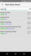
Users can search for geographic features, towns, mountain huts, and homesteads, making it easier to plan routes and navigate through diverse terrains. The application features simple text menus in English, ensuring that users can easily access the information they need without confusion. The straightforward interface minimizes the requirement for complex settings, making the app user-friendly for people of all skill levels.
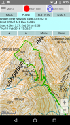
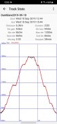
Track logging is a key functionality within AMap Viewer. Users can log their routes and save these logs as GPX files, enabling them to keep a record of their journeys. The app allows for the display of previously logged or imported tracks, showcasing data and statistics regarding each track. This includes time and distance measurements from the beginning and end of any chosen route, which can be beneficial for tracking progress and planning future outings.
AMap Viewer also features an editing tool that enables users to modify existing tracks or create new ones from scratch. This flexibility allows for personalized route planning, catering to individual preferences and requirements. Users can display information about any trackpoint, which aids in understanding the specifics of a journey.
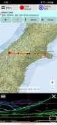
A unique aspect of AMap Viewer is its capability to draw the distant skyline, helping users identify peaks on the map. This feature enhances the outdoor experience by providing visual context for the surrounding landscape, which can be particularly useful in mountainous regions.
Additionally, the app supports the overlay of multiple maps, allowing users to view different layers of information simultaneously. This can be particularly useful when needing to compare various types of maps or when trying to gather more detailed information about a specific area. The variable density setting for overlays provides further customization, enabling users to tailor their viewing experience according to their preferences.
The application also includes a built-in help feature, which assists users in navigating the app and its various functionalities. This support is beneficial for new users who may be unfamiliar with the app's features, ensuring a smooth onboarding process.
For users interested in aerial photography, AMap Viewer offers online access to aerial imagery in New Zealand. This feature complements the topographic maps, providing an additional layer of information that can be helpful for trip planning and exploration.
In terms of permissions, AMap Viewer requires storage permission primarily for existing users who may have maps and tracks saved in various locations. New users benefit from a dedicated storage folder, simplifying the process. Location permission is necessary to utilize the map's tracking capabilities, allowing users to see their position on the map while logged in to track their progress.
AMap Viewer is designed to be lightweight yet powerful, ensuring that it runs smoothly on a variety of devices. The app's emphasis on user-friendly features and straightforward navigation makes it an excellent choice for those looking to explore both New Zealand and other countries.
The ability to download offline topographic maps is particularly advantageous for outdoor activities, as it ensures that users can access essential information regardless of their internet connection. This aspect makes AMap Viewer a reliable companion for adventurers in remote locations.
Users can find comfort in knowing that they have a comprehensive tool at their disposal, capable of supporting their outdoor pursuits in various terrains. The combination of map downloads, track logging, and customizable features positions AMap Viewer as a valuable resource for anyone seeking to enhance their exploration experiences.
Incorporating these functionalities, AMap Viewer provides a cohesive platform for navigation and outdoor adventure planning, making it an ideal choice for active individuals looking to enrich their journeys.
AMap Viewer - Version 41.0
(23-03-2025)AMap Viewer - APK Information
APK Version: 41.0Package: nz.ianrnz.AMapViewerLatest Version of AMap Viewer
Other versions


 4.28
4.28Apps in the same category


